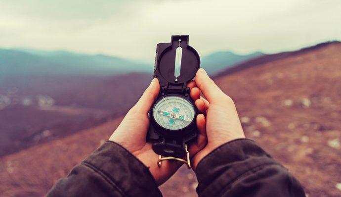
 Learning how to use a compass can seem needless in our age of technology. After all, we have GPS devices that can do the same work with less effort. Nevertheless, knowing how to use a compass is crucial when you’re planning a hike. A hiking GPS could run out of batteries. If you happen to drop it, it’s pretty easy to break, and a poor signal can render it useless. Without a backup plan, it’s easy to get lost in the woods and hard to get out. Part of this is physical. You have a dominant leg in the same way you have a dominant hand — in fact, they’re on the same side. This becomes problematic when you’re lost in the woods. Your dominant leg generally has a longer stride than the other, which often leads to walking in circles. Disorientation is also a problem. When you’ve been off-trail for a while, you’re bound to get scared and stop thinking logically. It becomes much harder to distinguish between new landmarks and ones you’ve already seen. The longer you’re lost, the more confused you get, and the more likely you are to make poor decisions that can lead to disaster. But by learning to use a compass, you guard against these dangers. You have reliable, effective tools at hand to make sure you can always find your way. Table of Contents
- The anatomy of a compass
- Necessary vocabulary
- How to use a compass
- How to use a compass with a map
- Dealing with obstacles
The anatomy of a compass
In order to know how to use a compass, first you need to understand is each of its parts:
- The base plate is the flat surface upon which the rest of the compass is mounted. It’s hard and rectangular so that it can stay level, which helps you get an accurate reading, and to assist in drawing straight lines on a map. There are rulers along its edges, and some base plates have scales. Both help you measure distance.
- The compass housing is a round plastic bubble that holds both liquid — usually alcohol — and the compass needle. The liquid allows the needle to rotate freely.
- The compass needle is a magnetized piece of metal. One end is usually painted red to mark “North.” It sits on a fine point that’s nearly frictionless, helping the needle to rotate easily through the liquid.
- The bezel is a rotating ring that surrounds the compass capsule. It’s marked with degrees (0 through 359), compass points (North, North-East, East, South-East, South, South-West, West, and North-West), or both.
- The orienting arrow sits inside the compass housing and rotates when the bezel is turned. When you take a compass bearing, you align it with the compass needle. It can also be used to make sure the compass needle is always pointing north, giving you the correct direction of travel.
- The direction-of-travel arrow is marked on the base plate and should always point toward your intended destination. It can also be used as an index line when taking your bearing reading.
- The index line is sometimes an extension of the direction-of-travel arrow. Other times it’s a black line inside the bezel or an arrow on the base plate. It’s used to take your compass bearing.
- Orienting lines sit inside the compass housing. They align with the horizontal lines on a map (easting lines) to make sure you align with grid north: the top of your map.
Necessary vocabulary
Whether you’ll be using a compass with a map or on its own, there are a few terms you’ll need to understand first. For instance, there are three ‘north’s when it comes to compasses and maps. ‘True north’ relates to where the physical north pole is and it’s actually not relevant when it comes to navigation. ‘Grid north’ refers to the top of your map, but instead of being a single point, it’s a line; it’s as if the world is flat and the entire top of the map counts as north. The last ‘north’ is ‘magnetic north,’ which is where the compass needle points. It’s controlled by the earth’s magnetic field. You also should know the basics of magnetic declination, or just ‘declination.’ This refers to the number of degrees between true north and magnetic north and whether they’re to the east or west of true north. If magnetic north is east of true north, the declination is positive, and if it’s west, the declination is negative. For example, the declination in Boston, MA (where I’m writing) is -14 degrees, since it’s 14 degrees west of true north. Declination changes over time because of normal magnetic activity, so make sure that if you’re using a map, it’s as current as possible to reflect the most recent declination readings. Speaking of maps, there are some words to learn — or review — if you want to use one with a compass:
-
- A compass rose is a symbol, usually a circle with points within it, that shows which way north, south, east, and west are on the map. It may also show north-east, north-west, south-east, and south-west.
- Latitude lines go east-west, i.e., horizontally across the map, and indicate how far north or south of the equator you are. On the other hand, longitude lines run north/south, i.e., vertically on the map, and indicate how far east or west you are of the prime meridian, which runs through Greenwich, England. If you have trouble telling them apart, think of ‘latitude’ as rungs on a ladder — which run horizontally.
- The map’s scale indicates how ‘zoomed in’ you are on the area. It’s usually written as “1:X,” which means that one unit on the map represents ‘X’ times that number off the map. The maps made by the United States Geological Survey (USGS) use a scale of 1:24,000, meaning that one inch on the map equates to 24,000 inches or about 0.38 miles in the outside world. There could also be a distance scale which shows how inches on the map correspond to real-life miles or kilometers.
- The year of production is the date on the map that shows when the data on the map was collected. This is important when determining whether the map is up to date and if the declination listed is still accurate.
- The year of revision is the date the map was updated. It may or may not exist, depending on if the map was revised.
- If there’s a ‘photo revised’ date on the map, this refers to the last time the map was updated based on photographs of the area.
- Contour lines trace geographic features to indicate their elevation. The contour interval is crucial to understanding what the contour lines mean. Like a distance scale, it shows what the difference in elevation between the contour lines is, so that you know the height of land features around you.
- The map’s legend explains what the symbols and colors on the map mean. Some common colors are black (manmade features), blue (water), brown (contour lines), green (areas of vegetation), white (areas with little-to-no vegetation), red (highways and boundaries of public lands), and purple (features added after the photo revised date).
How to use a compass
Now that you know the vocabulary, it’s time to put your skills to use:
- First, figure out where you want to go. Let’s say it’s a mountain. Face that.
- Hold your compass flat in your palm and hold your palm in front of your chest.
- Next, find out which way you’re facing. Look down at the compass needle to see which way the red point is facing — that’s magnetic north.
- Rotate the bezel so the orienting arrow points toward magnetic north. The place where the direction-of-travel arrow aligns with the compass point on the bezel shows which way you’re pointed. If your bezel has degrees instead of compass points, you’ll have to convert them to compass points. For your convenience, north is 0 degrees, northeast is 45, east is 90, southeast is 135, south is 180, southwest is 225, west is 270, and northwest is 315. More precise directions are in between. This is called getting your bearing.
- Now keep walking in the direction of your bearing. Every so often, repeat steps 1-4 to make sure you’re headed in the right direction.
How to use a compass with a map
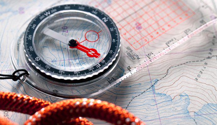 Using a compass with a map is similar to using a compass without a map — except you have an extra tool to assist you!
- Step 1: First, get what you need: your compass, map, a long piece of string, and the declination of the area. Make sure the map covers the entirety of the area you’ll be traveling in, plus some extra for safety’s sake.
- Step 2: Place your map on a level surface with north on the compass rose facing up. Use the string and the map’s scale/distance scale to determine how far you’ll be hiking. Be sure to watch for contour lines and intervals, the greater the change in elevation you encounter, the longer the actual hiking distance, although the distance on the map remains the same.
- Step 3: Put the compass on top of the map. Make sure you’re far away from any metal — this could mess with the magnetization of the compass needle.
- Step 4: The first step to taking a bearing is figuring out where you are on the map (point A) and where you want to go (point B). If you know where you are on the map, skip ahead to step 7. Otherwise, look around and find two easily identifiable landmarks, then find them on your map using the legend. Choosing unique landmarks is important here — you don’t want to misidentify a landmark and end up lost. Once you’ve found them both on your map, mark them as L1 and L2.
- Step 5: Hold the compass flat on your palm and hold your palm in front of your chest so that the direction-of-travel arrow points towards L1, then rotate the bezel until north (or 0 degrees) aligns with the northern end of the compass needle. Take the heading where the direction-of-travel arrow meets the bezel.
- Step 6: Next, put your compass on the map with the edge touching L1. Turn the base plate until the orienting lines inside the compass housing line up with the easting lines on the map. Then draw a line through L1 using the side of the base plate as a guide.
- Step 7: Repeat steps 4 and 5 using L2 instead of L1. When you’re through, you should have two intersecting lines on your map. The point where they cross is your location.
- Step 8: Now use the side of your base plate to line up point A and point B with the direction-of-travel arrow pointed toward B. If your base plate is too short, use a string to create the line and place the base plate alongside.
- Step 9: Turn the bezel so that 0 degrees or north point to grid north. The orienting lines should align with the easting lines on the map.
- Step 10: Now it’s time to account for declination. Let’s use mine: -14 degrees. Add 14 degrees from your bearing to account for the difference between magnetic north and grid north, i.e., to translate your work from the map to the real world. Always subtract a positive declination and add a negative one.
- Step 11: Lift the compass off the map and hold it flat in your palm with your palm in front of your chest. The direction of travel arrow should be facing away from you.
- Step 13: Rotate your whole body until the orienting arrow aligns with the northern tip of the compass needle. Do not move the bezel.
- Step 14: Once the needle and arrow are aligned, find a landmark along this bearing, walk until you get to it, and make sure the orienting arrow and compass needle are still properly aligned. Make corrections as necessary, and repeat this step until you reach point B.
Dealing with obstacles
Sometimes, despite the best-laid plans, you’re going to run into obstacles. A downed tree, a swampy area, or a large patch of ice could be a deal-breaker on your course — unless you know how to use a compass to go around. No need to panic, though. It’s actually a simple process:
- Stop when you reach the obstacle and take your bearing again, with a map or without.
- Then add or subtract 90 degrees from your bearing. Note: It doesn’t matter if you add or subtract. You’re just walking in a box-shape around the obstacle. However, if things look clearer to one side than another, set your bearing for the path that’s easier. For example, if your bearing was 170 degrees, your new bearing would be either 80 or 260 degrees.
- Now hike along your new bearing until you’ve cleared your obstacle. Make sure you keep track of the distance you’ve traveled. An easy way is to count your paces. Try to keep your steps even so that your count is reliable.
- Once you’ve cleared the obstacle, go back to your original bearing and walk forward until you’ve passed it on that line.
- Now add or subtract 90 degrees from your original bearing, the opposite of what you did in step 2. For example, if you changed your bearing to 80 degrees in step 2, change it to 260 now. If you changed it to 260 before, change it to 80 now.
- Walk along that path for the same number of paces you walked in step 3. This will bring you back to your original path.
- Finally, use your compass (with or without a map) to take a bearing toward your destination. Congratulations! You conquered the obstacle with nothing but a compass as your guide.
This is the power of learning to use a compass. It can help you stay on course, circumvent things obstructing your path, or even save your life. Now go out there and get one for yourself. Not sure how to pick one? We have tips for choosing a compass too! Practice in a place you know well until you’re comfortable, then enjoy the great outdoors knowing that you’ve got back-up if you need it.