When in Portland, it can be difficult to decide where to hike because there are so many amazing choices nearby. We’ve narrowed the list down to eight trails, so you can spend less time deliberating and more time in the outdoors. Whether you want to hike along the Oregon coast, trek through a verdant forest, climb a mountain, or feel the mist of a waterfall, it can be done within 100 miles of the city.
Hiking trails in Portland
Mt. Tabor Blue Trail
Distance from downtown Portland: 4.6 miles Length: 3 miles (3.31 if you add the summit loop) Type of Trail: Loop Elevation Gain: 280 feet (more if you add the summit loop) Difficulty: Moderate Family Friendly: Yes Best Seasons: All Trailhead Location: Mt. Tabor Visitor Center Parking Lot Don’t want to drive far or only have a couple of hours to squeeze in a hike? Take a stroll on an extinct cinder cone volcano! In southeast Portland, Mt. Tabor is a feature of the Boring Volcanic Field (yes, that is its real name) that envelops the city. Mt. Tabor Blue Trail encircles the nearly 200-acre Mt. Tabor Park and provides fantastic views on clear days: downtown Portland on one side, Mt. Hood on the other. It passes through forest and around three reservoirs. Make sure to grab a map at the Visitor Center or download one here, because the trail connects with many others throughout the park and can be hard to follow. This hike is rated as moderate because it includes lots of hills and stairs. If you’re up for more adventure — and more climbing — add on another third of a mile and trek up to Mt. Tabor’s summit via another loop trail that connects to the Blue Trail. Since this hike is in an urban park, it can easily get crowded on weekends; however, it’s a great place to experience nature in the middle of a city. In addition to numerous trails, Mt. Tabor Park also offers a playground, a dog park, and various sports courts, so bring the whole family.
Wildwood Trail
Distance from downtown Portland: 3 miles Length: Up to 30 miles Type of Trail: Point-to-point or out-and-back Elevation Gain: Varies Difficulty: Easy – Moderate Family Friendly: Yes Best Seasons: All Trailhead Location: Various Portland is an eco-conscious city full of nature lovers, so it’s no surprise that there’s a 5,200-acre wooded park within its midst. Nestled in northwest Portland, Forest Park is best explored by hiking a section (or all) of the 30-mile Wildwood Trail. Many trailheads provide access to the path, so it’s easy to choose your own adventure and jump on and off the trail at different locations. The Wildwood Trail is well maintained and close to downtown, making it an ideal place for Portlanders to go running or walk their dogs. Though the trail can be busy at times, it’s well worth exploring as it showcases a vibrant example of Oregon forest. According to Portland Parks & Recreation, “Forest Park is home to over 100 species of native birds and more than 50 mammals.” From flora to fauna, lot can be seen along the Wildwood Trail. To incorporate a bit of history into your hike, hop on the trail near Pittock Mansion, a Portland landmark. More than a century old, Pittock Mansion is an impressive structure that once belonged to the influential Henry Pittock, former owner of The Oregonian newspaper. Tours of the mansion are available all year except for January, and a panoramic view of Portland can be seen from its grounds.
Coastal hikes
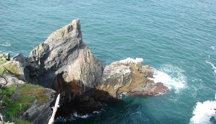
Cape Falcon Trail
Distance from downtown Portland: 88 miles Length: 5 miles round trip Type of Trail: Out-and-back Elevation Gain: 160 feet Difficulty: Easy Family Friendly: Yes Best seasons: All Trailhead Location: 45.76405, -123.95435 Oswald West State Park is an area where surfers and hikers alike converge to enjoy the Oregon coast in all its beauty. For a stunning panorama of the Pacific Ocean, hike to craggy Cape Falcon via an easy trail through an old-growth forest of giant Sitka spruce and meadows of high-growing salal. Along the way, the trail teases you with vistas of the sea (including Short Sand Beach), crosses a few small creeks, and passes a waterfall. It’s a dazzling landscape — even more so in the spring when wildflowers are in full display. Just make sure to wear quality hiking boots, as the trail is known for getting extremely muddy, especially during the rainy seasons. Want to spot a spout? Cape Falcon is a popular place to watch for gray whales. Whale-watching on the Oregon coast is a year-round activity, but best during migration seasons.
Clatsop Loop Trail
Distance from downtown Portland: 81 miles Length: 2.5 miles Type of Trail: Loop Elevation Gain: 800 feet Difficulty: Moderate Family Friendly: Yes Best Seasons: All Trailhead Location: 45.93017, -123.97749 Follow in the footsteps of Captain William Clark and head to the Clatsop Loop Trail, a scenic hike along a coastal headland between Seaside and Cannon Beach. Steeped in history, the Clatsop Loop Trail is a small segment of the Lewis and Clark National Historic Trail and is located in Ecola State Park. In 1806, Clark led a small exploration party (including Sacajawea) through the area and wrote about its splendor. The Clatsop Loop trail runs parallel to Indian Creek, providing plenty of opportunities to explore a riparian habitat. The first half of the hike is along an old road, and the second half follows a ridge top to the western face of Tillamook Head, where there are several viewpoints of the ocean and the rugged shoreline below. If you bring kids along, watch them closely, as there are steep drop-offs from the trail. Bonus trail: From Clatsop Loop’s midpoint at Hiker’s Camp, take a short spur trail to the Tillamook Rock Lighthouse viewpoint. You’ll pass the moss-covered remains of a World War II radar station and end up with a beautiful view of the ocean and “Terrible Tilly,” a lighthouse a mile out to sea that was nicknamed for how difficult it was to build.
Columbia River Gorge hikes
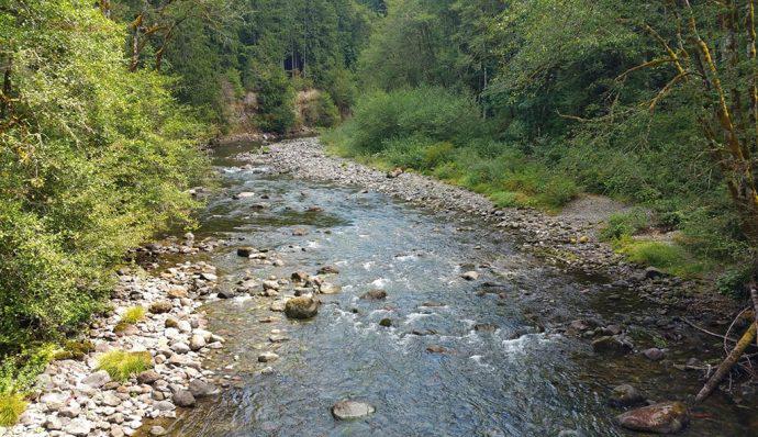
Wahclella Falls Trail
Distance from downtown Portland: 40 miles Length: 1.8 miles round trip Type of Trail: “Lollipop” — Out to a loop and back Elevation Gain: 350 feet Difficulty: Easy Family Friendly: Yes Best Seasons: All, except after a winter storm Trailhead Location: 45.63060, -121.95382 This is a short hike with a big payoff. It’s perfect for people who don’t have a lot of time to work with but still want to see what the Columbia River Gorge has to offer. Not surprisingly, this is a popular trail. Finding parking can be difficult, even in the winter, so head out on a weekday if possible for less congestion. The Wahclella Falls trail will take you along the gently flowing Tanner Creek, through a lush forest, past giant mossy boulders, and to the powerful two-tiered waterfall. It’s a magical fairyland that can be enjoyed even on a rainy day — and there are many. Bring snacks and take a break at the base of the waterfall. While this hike is family-friendly, there are a few switchbacks and steep banks, so keep a close eye on the tots.
Elowah Falls/Upper McCord Creek Falls Trails
Distance from downtown Portland: 37 miles Length: Elowah: 1.5 miles, Upper McCord Creek: 2.2 miles, Combined length of 3 miles round trip Type of Trail: Out-and-back Elevation Gain: Elowah: 260 feet, Upper McCord Creek: 600 feet, Combined elevation gain of 712 feet Difficulty: Easy/Moderate Family Friendly: Yes Best Seasons: All, except after a winter storm Trailhead Location: 45.6124, -122.00428 Why hike one trail when you could hike two, conveniently located next to each other? It’s definitely worth it. The Columbia River Gorge is sprinkled with impressive waterfalls, and Elowah Falls and Upper McCord Creek Falls are no exceptions. Even when combining two trails, this is a relatively easy hike. Both paths start at the John B. Yeon Trailhead, and they share the first half-mile or so. Then, the trail comes to a junction: Elowah to the left, Upper McCord Creek to the right. Start with the Elowah Falls trail, which leads to the base of a towering waterfall that pours into an amphitheater of layered basalt. It’s a majestic and misty place. On the Upper McCord Creek trail, you’ll climb steadily through forest, eventually coming to a bird’s-eye view of Elowah Falls. (I personally think seeing the waterfall from the ground first is the way to go.) The last stretch of this trail is blasted into a sheer cliff face and bordered by guardrails. Though this section offers spectacular vistas of the surrounding gorge and Upper McCord Creek Falls, it could be challenging or frightening for really little kids — or people who are afraid of heights.
Mt. Hood hikes
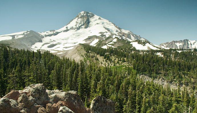
Cooper Spur Trail
Distance from downtown Portland: 87-99 miles, depending on route Length: 6.8 miles round trip Type of Trail: Out-and-back Elevation Gain: 2,800 feet Difficulty: Difficult Family Friendly: No Best Seasons: Late summer, early fall Trailhead Location: 45.4024, -121.6546 This challenging trail has a little bit of everything: incredible mountain and glacier landscapes, old-growth forest, tundra, and even a bit of history. The hike climbs up a portion of Mt. Hood, a volcano that rises to 11,245 feet — Oregon’s highest peak. Although Mt. Hood is an active volcano, its most recent eruption was in 1907, so don’t expect to see lava flows. Cooper Spur is the highest point on Mt. Hood that can be reached by a formal trail, at an elevation of 8,514 feet. To reach this location, start at the Cloud Cap Trailhead near the Cloud Cap Saddle Campground. This path quickly connects with the Timberline Trail #600, which then connects to the Cooper Spur Trail after about a mile. Shortly after the junction, look for a small stone warming shelter built by the Civilian Conservation Corps in 1934. Along the way, this spectacular hike will give you a close-up view of Eliot Glacier and its impressive icefalls. You’ll also be able to see Newton Clark Glacier and surrounding peaks such as Mt. Jefferson and Mt. Rainier on a clear day. Bring plenty of water and sunscreen, as most of the trail is exposed.
Umbrella/Sahalie Falls Loop Trail
Distance from downtown Portland: 75-98 miles, depending on route Length: 4.6 miles round trip Type of Trail: Loop Elevation Gain: 820 feet Difficulty: Moderate Family Friendly: Yes Best Seasons: Summer, early fall Trailhead Location: Elk Meadows Trailhead; 45.3231, -121.63575 If you like the thought of alpine meadows, mountain views, trickling streams, and waterfalls, this hike is for you. Plus, this tucked-away trail on the flank of Mt. Hood tends to be less busy than others near Portland. The hike winds through forests and meadows that burst with blooming wildflowers during July and August. Lupine, Indian paintbrush, and purple aster favor this area, and deer can often be seen grazing in these fields. Along the path, you’ll also crisscross several streams and two very different waterfalls: the lofty Sahalie and the tumbling Umbrella. This loop is actually the combination of sections of two trails — Sahalie Falls Trail #667C and Umbrella Falls Trail #667 — with a quick detour off of the loop if you want to see Umbrella Falls. Check out this map for more information. You’ll start at Elk Meadows Trailhead near where the map shows the numbers “3545” — more clearly seen by searching the trailhead on Google Maps. Hike the loop clockwise if you prefer an easier grade, counterclockwise if you want an uphill workout.