 When one thinks about hiking, often it’s alpine meadows and ridge lines, deeply forested trails, and sweeping canyons that come to mind. Mountainous areas of the U.S. are often protected for uninterrupted wilderness travel, and thus rife with trails. But, so are many of our coastal areas! In the spirit of new exploration, we’ve put together a list of some of the best ocean-side hiking the west coast, east coast, and the lake coasts in between have to offer.
Pacific Coast hikes
Kalalau Trail, Kauai, Hawaii
The Kalalau Trail is touted to be one of the most beautiful trails in the world, providing the only land access to the rugged Na Pali coast, where sea cliffs, lush valleys, and isolated beaches hold treasures of hidden waterfalls, abounding tropical plant species, and wild goats. The hike can be done as a long day out and back, but adventurers should allow for at least a few nights of camping on one of the beautiful beaches. Kalalau Beach, in particular, offers endless exploration — intrepid swimmers can swim to secluded beaches; hikers can explore the off-the-grid communities, gardens, and cascading waterfalls in the lush forests, and caves and tide pools are abundant.
- Location: the Na Pali coast in Ha’ena State Park, Kauai
- Trail type: dirt trail
- Distance: 22 miles out and back
- Elevation gain: 5,141’ elevation gain round trip
- Difficulty: Difficult. Additionally, some call the Kalalau Trail one of the most dangerous trails in the world; the trail at times skirts delicately around the exposed contours of sea cliffs.
- Best season: Year-round.
- Camping: There are two authorized camping areas along the Na Pali Coast — Hanakapi’ai and Kalalau.
- Family / dog-friendly: Older kids with hiking experience will enjoy this trail. Dogs prohibited.
- Permits: Permits are required to camp and to hike past Hanakapi’ai (even if you don’t plan to camp). Obtain a permit using the instructions provided on the Kalalau Trail website.
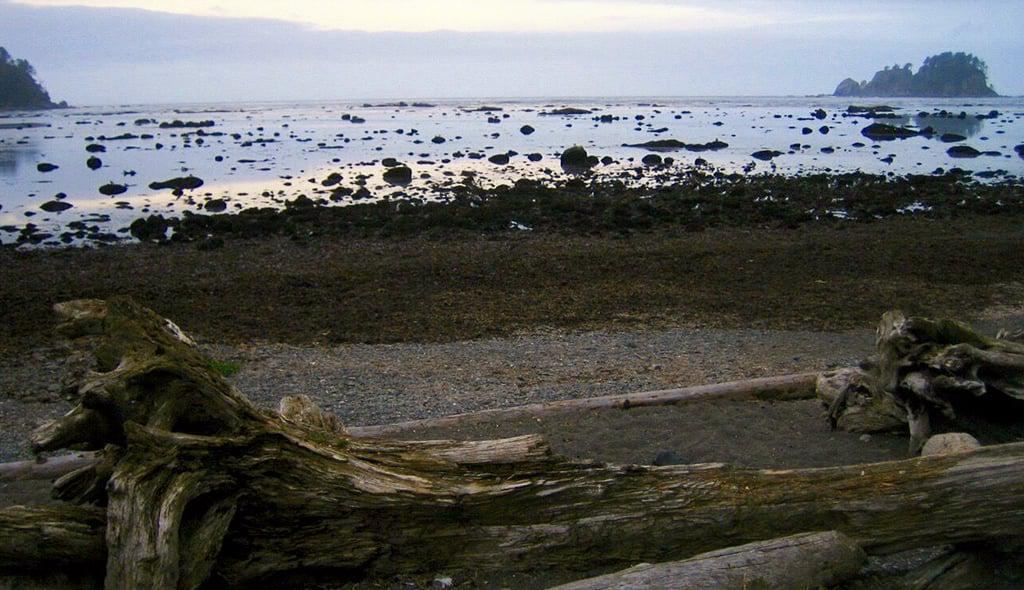
Ozette Triangle Loop, Washington
The Ozette Triangle Loop, also known as the Cape Alava Loop, comprises the best of both worlds in Olympic National Park — the ecologically diverse rain forest and the rugged, open coastline. The hike is a loop, yet best described as a triangle for its three prominent legs, a trio of trails connected by the Ozette Campground, Sand Point, and Cape Alava, each about three miles apart. The treed sections of the trail feature boardwalks, stairs, and passage through a fern-filled rainforest; the beach section of the trail passes petroglyphs and driftwood obstacles, enjoying the westernmost piece of coastline in the lower 48.
- Location: Olympia National Park, Washington
- Trail type: beach, dirt trail, boardwalk
- Distance: 9.2 mile loop
- Elevation gain: ~100'
- Difficulty: Moderate
- Best season: Late May - early October
- Family / dog-friendly: Excellent choice for a multi-day backpacking loop with children. Dogs prohibited.
- Permits: National Parks Pass needed for entry into Olympic National Park. Free Wilderness Camping Permits required year-round; reservations required between May 1 and September 30.
- Camping: The primary camping destinations are Sand Point and Cape Alava.
Crescent Beach Trail, Oregon
Ecola State Park lies on one of the most beautiful stretches of coastline in Oregon, between Seaside and Cannon Beach. Crescent Beach is arguably the gem of the park, a secluded sandy beach where one can discover tide pools; view wildlife such as deer, elk, eagles, and even whales; and watch waves slam against the sea stacks offshore. The trail to Crescent Beach is rolling and rugged, offering views of the coastline while dipping in and out of the forest. If you’re visiting Portland, there are a number of hiking options nearby.
- Location: Ecola State Park, Oregon
- Trail type: dirt trail
- Distance: 2.5 miles out and back
- Elevation gain: ~200’ elevation gain round trip
- Difficulty: Moderate
- Best season: mid-April - October
- Family / dog-friendly: Family-friendly; dogs allowed on leash.
- Permits: No permits needed; a parking fee is required.
Lost Coast Trail, Mattole to Black Sands Beach Section, California
California’s coastline, while beautiful, can be extremely populated and developed. Not the Lost Coast. The Lost Coast comprises 80 miles of California’s most undeveloped stretch of shoreline (the longest stretch of undeveloped US Pacific coastline outside of Alaska) where Highway 1 developers built the road inland on more moderate terrain. What has resulted is desolate, rugged coastline where nature is still pristinely intact. Adventurous hikers can spend the entire 3-4 days on the trail without seeing another soul, yet enjoying scores of wildlife, challenging obstacles, and miles of deserted beaches. Going on a hiking trip to California? Don’t miss these other great hiking trails!
- Location: Lost Coast Trail, near Ferndale, CA
- Trail type: sandy and rocky beach
- Distance: 25 miles one way, car shuttle required
- Elevation gain: minimal
- Difficulty: Strenuous. This trail is committing in length, and walking on sand and slippery rock is physically taxing. Additionally, be sure to bring a tide chart and know how to read it—the trail can become impassable at high tide.
- Best season: Late May - early October
- Family / dog-friendly: Only seriously adventurous families will enjoy this adventure; dogs allowed but not recommended due to the abrasive nature of the sand known to aggravate dogs’ pads.
- Permits: Required. Free permits are available via self-registration at the major trailheads and BLM offices.
- Camping: Camping is available where any stream meets the ocean.
Atlantic Coast hikes
Parallel Trail, Cumberland Island, Georgia
Cumberland Island is Georgia's largest and southernmost barrier island, and home to over 9,800 acres of congressionally designated wilderness. The island is known for its pristine coastline, Spanish moss covered trees, and wild horses, in addition to armadillos, ruins, and a historical mansion dating back to the late 1890s. The Parallel Trail runs south to north on the island, starting in Sea Camp, where hikers disembark the ferry and can obtain an orientation and camping permit. It journeys through tree-canopied trails for a sizable portion of the island, offering access to numerous other roads and trails, and the beaches on the east coast of the island.
- Location: Cumberland Island National Seashore, Georgia
- Trail type: wide dirt trail, beach
- Distance: 15 miles round trip
- Elevation gain: ~200'
- Difficulty: Easy
- Best season: Year-round.
- Family / dog-friendly: Excellent choice for a backpacking trip with children. Dogs are allowed on the island but not on the ferry or campsites.
- Permits: Ferry and campsite reservations are almost always required, and fill up weeks to months in advance. Visit the NPS website to make reservations.
- Camping: The island’s three backcountry sites include Hickory Hill, Yankee Paradise, and Brickhill Bluff.
Ocean Path, Maine
With mountains, lakes, woodlands and islands, Acadia National Park on the coast of Maine is not to be missed. The Ocean Path explores arguably the crown jewel of the Park — the coastline. This trail offers passage from Sand Beach to Otter Point, but also provides explorers access to many high points, coastal sites, and beaches along the way. One of the highlights of the trail is Thunder Hole, a rock feature which, when water flows through at the right speed, sounds a clap of thunder that can be heard from far away.
- Location: Acadia National Park, Maine
- Trail type: gravel trail
- Distance: 4.2 miles round trip
- Elevation gain: ~400'
- Difficulty: Easy
- Best season: mid-April - October
- Family / dog-friendly: Family-friendly. Dogs permitted on leash.
- Permits: NPS pass required to enter park
Florida Trail, University of Western Florida Dunes Preserve
The Florida Trail is one of eleven National Scenic Trails in the United States, running 1,000 miles through the state. The section of the trail running through the UWF Dunes Preserve on Santa Rosa Island is dramatically different from other sections of the trail, and a unique way to see the coastline of Florida. Follow orange markers on this trail and travel exclusively on sand over beaches and dunes, with spectacular views of ocean and bay on either side of the island.
- Location: University of Western Florida Dunes Preserve, Florida
- Trail type: beach sand
- Distance: 3.4 miles round trip
- Elevation gain: minimal
- Difficulty: Moderate
- Best season: Year-round
- Family / dog-friendly: Family-friendly. Dogs permitted on leash.
- Permits: n/a
Great Lakes hikes
Scoville Point Loop, Lake Superior
Isle Royale National Park is a remote island cluster in Lake Superior, a car-free swath of wilderness between Michigan and Canada where even moose and wolves can be found. The Scoville Point Loop highlights some of the most dramatic coastline in the park, winding back and forth between old growth forest and craggy coastline, ending at the sweeping views of Scoville Point.
- Location: Isle Royale National Park, Michigan
- Trail type: dirt trail
- Distance: 4.4 miles round trip
- Elevation gain: ~100’
- Difficulty: Moderate
- Best season: May - October
- Family / dog-friendly: Family-friendly. Dogs prohibited.
- Permits: NPS pass required for entry to Park
Empire Bluffs Trail, Lake Michigan
Sleeping Bear Dunes National Lakeshore was named the “Most Beautiful Place in America” by ABC’s Good Morning America, and with about 100 miles of trails through forest, beside lake, and over the area’s famous sand dunes, it’s a hiker’s paradise. Visitors can even take a ferry to the North and South Manitou Islands for more hiking trails. The Empire Bluffs Trail is a great intro trail to the park: the route winds through a beech-maple forest to a beautiful, centrally located vantage point about 400 feet above the beach, providing views both north and south on the coast. Hikers will also find six interpretive posts along the trail and can pick up an accompanying brochure that explains the natural and geological history of the area.
- Location: Sleeping Bear Dunes National Lakeshore, Michigan
- Trail type: boardwalk, paved gravel trail
- Distance: 1.5 miles round trip
- Elevation gain: ~100’
- Difficulty: Easy
- Best season: May - October
- Family / dog-friendly: Family-friendly. Dogs prohibited.
- Permits: NPS pass required for entry to Park
Be prepared for your coastal hike
Whether you’re on the west coast, the east coast, or the lake coasts in between, maritime climates have one thing in common: water. Water often covers the trails and frequents the cloud-covered skies above. You’ll want to plan accordingly with your choices of clothing and gear. Footwear is where it all starts; we recommend waterproof hiking shoes for stream crossings, wet trails, and exploring near the waves. Wear layers so that you can add or subtract warmth as you hike, including a waterproof shell. And finally, always bring water and food, and the Ten Essentials that apply to your hike.